Footpaths and Woodlands
*July 2024
More on Black Isle Footpaths - Julian Paren
Julian Paren has made a photographic record of all the core paths on the Black Isle, and used the imagery in a compilation of the Black Isle Core Paths, together with links to the appropriate maps. This compilation is an on-line article on the Geograph website, for which Julian has written this introduction:
"Did you know that Highland Council has given special protection to 71 footpaths on the Black Isle? These paths are the Core Paths of a Highland-wide network. Highland Council describes the nature of the paths as:
"Core Paths can be paths, waterways or any other means of crossing land to facilitate, promote and manage the exercise of access rights under the Land Reform (Scotland) Act 2003. Core Paths provide a basic framework of routes for the purpose of giving the public reasonable access throughout a particular area for walking, cycling, horse riding and other non-motorised activities.
"Each of the images in the article can be displayed at higher resolution by clicking on the image. The images are available to download (up to 1600 pixels wide) and can be used free of charge, as they are covered by a Creative Commons License. If you would like more information please contact Julian. julian.paren@gmail.org.uk "
The Geograph article is at
https://www.geograph.org.uk/article/Core-Paths-on-the-Black-Isle
-------------------------
January 2023
Footpaths of the Black Isle - Julian Paren
TBI's former Convenor, Julian Paren, is a keen walker and photographer, and 'collects' Black Isle walks and woods, and records them, with pictures, on the website of a project called 'Geograph® Britain and Ireland', which 'aims to collect geographically representative photographs and information for every square kilometre of Great Britain and Ireland'.
Julian has contributed information for a large number of Kilometre squares on the Black Isle, and has recently comblned some of these into two articles on footpaths and woodland of the Black Isle. In addition to the online versions of these, which he likes because he can add to or update them at any time Julian has prepared static document versions, without images, which he hopes to have published in the Culbokie 'Chatterbox' and perhaps 'Muir Matters'.
Julian has kindly made copies available for us to publish on the website.
'Footpaths of the Black Isle'
Geograph version
Document version (PDF)
'Woodland of the Black Isle'
Geograph version
Document version (PDF)
-------------------------
August 2021
TBI leads the way to improve the John o’ Groats Trail by Munlochy Bay
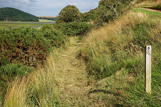
The first stage of the 10-stage John o’ Groats Trail from Inverness to John o’ Groats passes from Ord Hill behind North Kessock, beside Loch Lundie and then down to the shore of Munlochy Bay before heading on to Culbokie for the end of Day1. The route beside Munlochy Bay was conceived in 2015 to use a section of a Core Path of the Highland Core Path Network () but beside the bay the Core Path is waterlogged by both flooding by rainwater and from high tides. So by 2017 a higher route was constructed to bypass the lower wet section below Bayhead. After a year or so of operation, a footpath group that attracted members from across the Black Isle walked the route with pruners, loppers, secateurs and ensured it was safe and hazard-free to use.
Now forward to 2021 after a period of lockdown the route was barely walked and vegetation reasserted itself, especially in the cut section above Munlochy Bay. Julian and Mary Paren had tried to walk the section in July and gave up after fighting through gorse and brambles and long grass which hid the unevenness of the trail.
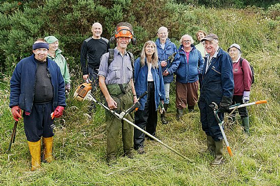
Julian sent out a call to the “footpath group” - an e-mail list of 35 people who had expressed an interest in maintaining footpaths, and ten days later, at short notice, 9 signed up for a fresh look at the section together with Jay Wilson, the originator of the entire John o’ Groats Trail. Unexpectedly (or maybe just what you would expect) all in this group were members of Transition Black Isle.
The problem section was possibly 400 metres long. The path was cleared from both sides and from low lying branches above, and on the ground by a final strim after the roots of gorse bushes had been cut right back to the ground. The section also had a problematic stile which was singularly difficult to use as there was still barbed and chicken wire across it. Fortunately an alternative route was seen to be possible, and was literally cut from scratch to follow the line of the fence which it crossed at a far easier point lower down. The new route is drier than the previous route over the stile and provides a shorter section off the Core Path than hitherto.
The weather was fair and all found a role with the implements they brought. Greatest thanks must go to Peter Moffatt for strimming the entire route after it had been opened up by those ahead of him.
At the end of activities, a photo was taken, home-made food shared, and Jay talked about the future of the Trail, highlighting that recent funding had allowed the employment of a Trail Manager, taking over some of the responsibility that Jay had taken on over the years.
Julian Paren

The cleared path

The team
-------------------------
Latest News...
 THURSDAY 20 MARCH was World Rewilding Day
Thursday 20 March Worldwide
World Rewilding Day was lau... More >>
THURSDAY 20 MARCH was World Rewilding Day
Thursday 20 March Worldwide
World Rewilding Day was lau... More >>Forthcoming Events…
- Saturday 29 March
- 10:00 North Kessock Community Market
- Tuesday 1 April
- 11:00 'Green Tourism' webinar
- Thursday 3 April
- 19:15 TBI trustees meeting
- Friday 4 April
- 09:30 Allangrange workshop - Introduction to biodynamic growing
- 16:00 Culbokie Green - Toilets and Potting Shed preview
- Monday 7 April
- 14:00 Highland Community Led Local Development Fund Briefing
- Saturday 12 April
- 10:30 Cromarty Community Market
- Saturday 19 April
- 10:00 Cukbokie Community Market
Events to add to calendar? Contact Us.
TBI Business Directory
Add Your Business
Do you run a sustainable business on or near the Black Isle? Add it to the TBI business directory
Browse Directory
- Accommodation (3)
- Crafts (9)
- Health and fitness (8)
- Home improvements (17)
- Local food suppliers (18)
- Miscellaneous (35)
- Renewable energy (18)


